Afficher les articles écrits par Emma Tonkin
Making maps
Posted on août 20, 2014, 6 après-midi by Emma Tonkin
Research materials on this site include a map displaying the political geography of medieval Aquitaine. While a useful resource in its own right, the map is difficult to overlay directly onto a user interface for various reasons:
* It is based on IGN maps, which use the Lambert projection, while in general (as previously discussed), we tend to use WGS-84. This leads to variations that are individually quite small, but visible in aggregate.
* It is a raster image (even ...
Visualising spatial data
Posted on août 14, 2014, 9:15 après-midi by Emma Tonkin dans Posts in English
In earlier posts in this series, we covered the geocoding of French locations and discussed the shape of the resulting dataset. To recap briefly:
- Place entities are resolved into a geographic point. We do not at this stage consider the boundaries or area of a given region; we simply look up the centrepoint of the region in question in a large lookup table and, metaphorically, stick a pin in the map at that point.
- The coordinates of each ...
Interpreting geocoded data
Posted on août 10, 2014, 1:11 après-midi by Emma Tonkin dans Posts in English
In the first post of this series, we covered the geocoding of entities in metropolitan France using INSEE data and entity data provided by expert indexers.
This process rapidly generates a large number of data points. Even though the currently published Gascon Rolls contain only a subset of the full dataset, there are already many thousands of unique entities encoded into the XML. A large subset of ...
First steps in geocoding
Posted on août 5, 2014, 11:15 matin by Emma Tonkin dans Posts in English
As part of the calendaring process, historians working on the Gascon Rolls routinely identify and encode a variety of types of entity: people, places, things, entry type and so forth. This information, whilst useful in itself, may be considered most useful when placed in a broader aggregate context. How did things change throughout the life of this foothold of English royalty in France? Did the focus move over time, from one town to another, or from one wealthy family to ...
A medieval Gascon view of Europe
Posted on juil. 5, 2014, 1:07 matin by Emma Tonkin dans Posts in English
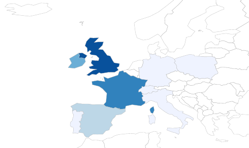
In which countries did the administration take an interest?
To answer this question, we will use RWorldmap, a library that I have mentioned in previous posts. RWorldmap is at its best when used for visual analytics.
The illustration below is a map showing the frequency of reference to different countries in the published Gascon Rolls.The darker blue the country, the more prominently it features in the Rolls.

- Page 1 sur 2
- ←
- 1
- 2
- →